Mountainous area situated at the northern extremity of the catalan Prelitoral mountain chain, astride the regions of la Selva (Girona) and Osona (Barcelona). The area included within the Pla d'Espais d'Interès Natural (PEIN), and therefore subject to a basic level of ecological protection, is of almost 12,500 ha. According to the limits set out in this document, within the region of Girona this includes parts of the municipalities of Osor, Sant Hilari Sacalm, Susqueda, la Cellera and Amer.
 The massif is located to the south of sector of el Collsacabra (which forms part of the Transversal mountain chain) and lies on the southern side of the river Ter and the dam of Susqueda. To the west of Les Guilleries there is the mountain of Savassona, to the south the Arbúcies river, which acts as a natural frontier between les Guilleries and el Montseny, although the limits defined in the PEIN go no further than the villages of Espinelves and Sant Hilari Sacalm. Finally, to the east are the plains of la Selva and el Gironès.
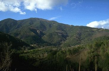
The massif consists mainly of granite and metamorphic rock, which give rise to a mountainous landscape with gently rounded summits. The highest points are those of Sant Gregori (1,094 m), la Guàrdia (1,129 m), Sant Benet and la Coma (1,149 m), el Faig Verd (1,187 m) and Sant Miquel de Solterra (or Sant Miquel de les Formigues) (1,202 m), which is the highest point of les Guilleries. Throughout these mountains there is a complex network of streams and rivers which flow all year round. These rivers divide the mountain range into various units. Amongst these river courses there are the voluminous river Ter, the river Major, the river of Osor, which has a roughly central position, and the river of Santa Coloma, which drains the most southern slopes. The massif rises from a height above sea level of about 300 m.
Although les Guilleries lies within the Prelitoral mountain range and is therefore subject to a certain mediterranean influence, the climate is relatively cool, with an average temperature of less than 12ºC and a high rainfall, the annual average being 800-900 mm, with maximum precipitation in summer and autumn. Relatively high and variable altitudes and many changes in the orientation of the slopes give rise to a mainly forested landscape, in which a marked mediterranean character combines with that of central-european.
The humid forests of les Guilleries have traditionally been cut for timber. For this reason the original forests have widely replaced by fast-growing species of higher productivity. Although the chestnut, which has been grown here expressly for harvesting, integrates harmoniously with the deciduous forest, there is no doubt that the intensive commercialisation to which large areas of the massif have been subjected constitutes one of the principal damages from which the zone now suffers. In addition to this, the large increase in the number of forest paths and the introduction of foreign trees is often at variance with the original forest species.
In the extreme north of les Guilleries the deep and narrow River Ter has been dammed to form the reservoirs of Sau, Susqueda and el Pasteral. This system of dams, aside from their importance in the distribution of water and the generation of electricity, has provided an element of attraction to the massif. Due to its mountainous forests les Guilleries was previously considered an inhospitable area and was largely unknown. As a result there are many legends and stories about the region, many of them about thieves and bandits. One of these is that of the most famous outlaw of Catalonia, Joan de Serrallonga (C. XVII), who became a popular literary figure.
With the building of the new highway between Girona and Vic (l'Eix Transversal de Catalunya) in 1995, a large part of the forest unknown to city dwellers was opened up to public view. Unfortunately, the building of the road had a significant environmental impact on the southern slopes of les Guilleries, although great efforts were made to minimize the damage.
To see the area we suggest starting from the village of Osor and taking the winding road towards Sant Hilari Sacalm, a municipality famous for the quality of its mineral water. Alternatively, from Osor one can take an unsealed track up to the col of Nafré, from which there is a good view of the Susqueda dam and the abrupt cliffs of el Collsacabra. Higher up there is the romanic sanctuary of el Coll, just below the peak at Sant Benet. From this point there is a wonderful view of the whole of les Guilleries and particularly the valley of Osor and its surrounding mountains. Another interesting route is from Santa Coloma de Farners, through the village of Castanyet and the area of Sobirà, and up to the village of Sant Hilari Sacalm. From this road, which traverses thick forest typical of the zone, there is a track which climbs up to Sant Miquel de Solterra, also known as Sant Miquel de les Formigues.